Exporting!
Exporting the current scene
See there:

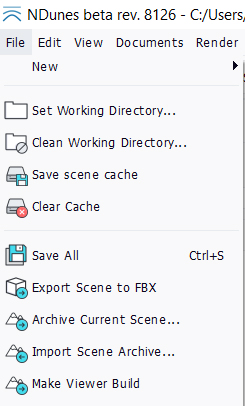
Click onto File / Export scene to FBX and then select the folder of the file to export.
Export steps
There are several steps to get through the export process:
- Updating world,
- Filtering landscape mesh,
- Splitting landscape mesh,
- Extracting plants,
- Extracting geometries,
- Saving output files.
Some of these steps may take some time depending on the amount of data being processed. Specifically, exporting millions of plants will take a lot of time.
Exported files
A complete file structure is being exported for a given scene. It contains the following files:
- A list of "Landscape_x_y.fbx" files. Each file is a separate tile in the export.
- A list of FBX files for each source plant in the biomes of the scene. Each plant has to be seeded according to positions found in the "Plants_x_y.xml" files that list all instances of all plants for the tile number ( x, y ).
- A list of geometry FBX files. Note that cities are split using sub-files: typically one sub-file per building or road part.
- A "Configuration.xml" file that'll detail the contents of the export, provide placement informations for each geometry.
- 'Vertex_shader.txt' and 'Pixel_shader.txt' are the vertex and pixel shaders (in GLSL) that can be used to reconstruct the landscape. The terrain blending equations are in the shader code and can be reused directly to rebuilt the landscape in a 3rd party application.
Please note that due to the roundness of the planets, axis systems of instanced geometries are near the +z vertical, but are not exactly equal to +z. At a few kilometers distance, the vertical slightly varies, so values found in xml files should be read "as is" and treated as double precision.
Exported plants
Plants are instanced through xml files that provide all position, rotation and scaling informations to use.
In the case of a .FBX file export, all supported maps are exported (diffuse, reflectance, normal, transmission). Translucency, back diffuse are not supported by the FBX format.
Each category of plant requires a minimal mesh subdivision of the terrain to be generated and thus exported. This is for the accuracy of the seeding of plants. For instance a grass layer of plants with patches that are 20 x 20 centimeters will not be generated if the landscape mesh triangle size used is 10 meters. We won't have enough accuracy to properly scatter all plants over the landscape. The list of plants that'll be actually exported can be viewed simply by turning on the visualization of the export area.
 Defining an export area contents Defining an export area contents | Synchronizing with NDunes |


